Amigo | |
|---|---|
 Amigo, West Virginia | |
| Coordinates: 37°35′19″N 81°20′50″W / 37.58861°N 81.34722°W | |
| Country | United States |
| State | West Virginia |
| County | Raleigh |
| Elevation | 1,580 ft (480 m) |
| Time zone | UTC-5 (Eastern (EST)) |
| • Summer (DST) | UTC-4 (EDT) |
| ZIP code | 25811 |
| GNIS feature ID | 1534921[2] |
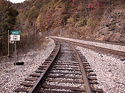
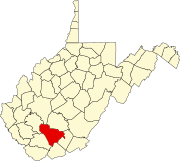
Amigo is an unincorporated community in Raleigh County, West Virginia, United States.[3] The community is located on West Virginia Route 16 at the confluence of the Guyandotte River and Winding Gulf.[4] The Amigo Post Office closed on October 22, 2011; it was established in 1915.[5]
Amigo Coal Company
The community most likely derives its name from the Amigo Coal Company, based on a conversation with the principal at Amigo in 1935.[6]
The Amigo Coal Company is listed in the "Annual Report of the Department of Mines For the Fiscal Year Ending June 30, 1920" in Raleigh County with company name "Amigo Coal Company", mine name "Amigo", and post office "Amigo".[7]
References
- ^ Rhodell, WV, 7.5 Minute Topographic Quadrangle, USGS, 1967
- ^ U.S. Geological Survey Geographic Names Information System: Amigo, West Virginia
- ^ "Amigo". Geographic Names Information System. United States Geological Survey, United States Department of the Interior.
- ^ Raleigh County, West Virginia General Highway Map (PDF) (Map). West Virginia Department of Transportation. 2011. p. 3. Archived from the original (PDF) on April 25, 2012. Retrieved December 12, 2011.
- ^ http://webpmt.usps.gov/pmt015.cfm[permanent dead link]
- ^ Kenny, Hamill (1945). West Virginia Place Names: Their Origin and Meaning, Including the Nomenclature of the Streams and Mountains. Piedmont, WV: The Place Name Press. p. 79.
- ^ "Annual Report of the Department of Mines For the Fiscal Year Ending June 30, 1920". June 30, 1920. Retrieved July 19, 2020.
External links
![]() Media related to Amigo, West Virginia at Wikimedia Commons
Media related to Amigo, West Virginia at Wikimedia Commons


