| City of Mount Gambier South Australia | |||||||||||||||
|---|---|---|---|---|---|---|---|---|---|---|---|---|---|---|---|
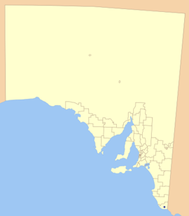
 Location of the City of Mount Gambier in blue | |||||||||||||||
| Population | 26,276 (2016 census)[1] | ||||||||||||||
| • Density | 85.31/km2 (221.0/sq mi) | ||||||||||||||
| Established | 1876 | ||||||||||||||
| Area | 308 km2 (118.9 sq mi) | ||||||||||||||
| Mayor | Lynette Martin | ||||||||||||||
| Council seat | Mount Gambier | ||||||||||||||
| Region | Limestone Coast[2] | ||||||||||||||
| State electorate(s) | Mount Gambier | ||||||||||||||
| Federal division(s) | Barker | ||||||||||||||
 | |||||||||||||||
| Website | City of Mount Gambier | ||||||||||||||
| |||||||||||||||
The City of Mount Gambier is a local government area centred in Mount Gambier in the Limestone Coast region of South Australia. While it is the southernmost city council in the state, the District Council of Grant is the southernmost council because it completely surrounds but does not include the city of Mount Gambier. It was established on 25 May 1876 as the Corporate Town of Mount Gambier, and became the City of Mount Gambier when it gained city status in 1955.[3][4]

The city consists of a mayor and eight councillors, elected equally from the East and West wards once every four years by postal voting. In addition to Mount Gambier itself, the council also includes parts of Glenburnie, OB Flat, Suttontown and Worrolong, all shared with the District Council of Grant.[5] Due to the City being entirely surrounded by the District Council of Grant and the growth of Mount Gambier, there have been ongoing talks of amalgamation, with the most recent boundary changes taking place in 2010.[6]
Mayors of Mount Gambier
[edit]- John Watson (1876-1878)
- George Wyatt (1878- 1879)
- Robert Anderson (1879- 1881)
- Thomas H. Williams (1881- 1882)
- Samuel Titus Webb (1882- 1883)
- A. F Laurie (1883- 1884)
- Lucas Adolphus DeGaris (1935-1937) [7]
- William Ewart Pyne (1937-1939) [7]
- Stanley Charles Davis (1939-1941) [7]
- William Ewart Pyne (1941-1945) [7]
- Stanley Charles Davis (1945-1946) [7]
- William Ewart Pyne (1946-1949) [7]
- John Hugh Marks (1949-1955) [7]
- Stanley Charles Davis (1955-1958) [7]
- John Hugh Marks (1958) [7]
- Stanley Hamilton Elliott (1959-1964) [7]
- Lenora Alice Bishop (1964-1967) [7]
- Stanley Hamilton Elliott (1967-1971) [7]
- Archibald Llewellyn Sealey (1971-1983) [7]
- Francis Newman (Don) McDonnell (1983-2002) [8][7]
- Steve Perryman (2002-2014) [9]
- Andrew Lee (2014-2018) [10]
- Lynette Martin (2018-present)
References
[edit]- ^ Australian Bureau of Statistics (27 June 2017). "Mount Gambier (C)". 2016 Census QuickStats. Retrieved 29 November 2017.
- ^ "Limestone Coast SA Government region" (PDF). The Government of South Australia. Retrieved 10 October 2014.
- ^ Marsden, Susan (2012). "A History of South Australian Councils to 1936" (PDF). Local Government Association of South Australia. p. 41. Archived from the original (PDF) on 17 March 2016. Retrieved 30 October 2015.
- ^ "Mount Gambier City Status Celebrations". State Library of South Australia. Retrieved 9 April 2016.
- ^ "Search result for "Mount Gambier (Locality Bounded)" (Record no SA0046869 ) with the following layers selected - "Suburbs and Localities" and "Local Government Areas"". Department of Planning, Transport and Infrastructure. 31 March 2010. Archived from the original on 12 October 2016. Retrieved 7 March 2016.
- ^ "Consolidation in Local Government: A Fresh Look - City of Mount Gambier and District Council of Grant | IKEN". Archived from the original on 30 December 2012. Retrieved 18 October 2012.
- ^ a b c d e f g h i j k l m n Matthews, Penny (1986), South Australia, the civic record, 1836-1986, Wakefield Press, p. 355, ISBN 978-0-949268-82-2
- ^ "Issue 50 - October 2002" (PDF). LGA News. Local Government Association of South Australia. Archived from the original (PDF) on 14 May 2013. Retrieved 21 November 2016.
- ^ "Mayoral duties done". The Border Watch. 23 October 2014. Retrieved 21 November 2016.
- ^ "Andrew Lee doorknocks his way into Mount Gambier's top job". Australian Broadcasting Corporation. 10 November 2014. Retrieved 21 November 2016.
37°49′45″S 140°46′48″E / 37.8291666667°S 140.78°E


