Essequibo_River_in_1826_Río_Esequibo_en_1826_Gran_Colombia_and_British_Guiana.jpg (664 × 560 pixels, file size: 96 KB, MIME type: image/jpeg)
| This is a file from the Wikimedia Commons. Information from its description page there is shown below. Commons is a freely licensed media file repository. You can help. |
Summary
| DescriptionEssequibo River in 1826 Río Esequibo en 1826 Gran Colombia and British Guiana.jpg |
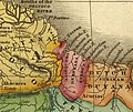
Español: El Río Esequibo en 1826 frontera entre la Gran Colombia y la colonia de la Guayana Británica, tambien se muestran los Rio Mazaruni y Cuyuni, y la Punta Barima.
English: The Esequibo River in 1826, the border between Great Colombia and the British Guiana colony, also shows the Mazaruni and Cuyuni Rivers, and Punta Barima. |
| Date | |
| Source |
Cropped from: File:Map of South America According to the Latest and Best Authorities. LOC 98687101.jpg File:Map_of_South_America_According_to_the_Latest_and_Best_Authorities._LOC_98687101.jpg |
| Author | Finley, A. (Anthony); Finley, A. |
Licensing
| Public domainPublic domainfalsefalse |
|
This work is in the public domain in its country of origin and other countries and areas where the copyright term is the author's life plus 70 years or fewer. This work is in the public domain in the United States because it was published (or registered with the U.S. Copyright Office) before January 1, 1930. | |
| This file has been identified as being free of known restrictions under copyright law, including all related and neighboring rights. | |
https://creativecommons.org/publicdomain/mark/1.0/PDMCreative Commons Public Domain Mark 1.0falsefalse
Captions
Items portrayed in this file
depicts
1826
image/jpeg
98,120 byte
560 pixel
664 pixel
1594b8521fa0cd2852c43ce8fe5ee50e680c3dcd
File history
Click on a date/time to view the file as it appeared at that time.
| Date/Time | Thumbnail | Dimensions | User | Comment | |
|---|---|---|---|---|---|
| current | 17:31, 5 October 2020 |  | 664 × 560 (96 KB) | Warairarepano&Guaicaipuro | Uploaded a work by Finley, A. (Anthony); Finley, A. from Cropped from: File:Map of South America According to the Latest and Best Authorities. LOC 98687101.jpg https://commons.wikimedia.org/wiki/File:Map_of_South_America_According_to_the_Latest_and_Best_Authorities._LOC_98687101.jpg with UploadWizard |
File usage
The following 2 pages use this file:
Global file usage
The following other wikis use this file:
- Usage on es.wikipedia.org
Metadata
This file contains additional information, probably added from the digital camera or scanner used to create or digitize it.
If the file has been modified from its original state, some details may not fully reflect the modified file.
| Author | Wilmer |
|---|---|
| Date and time of data generation | 13:24, 5 October 2020 |
| Date and time of digitizing | 13:24, 5 October 2020 |
| DateTimeOriginal subseconds | 58 |
| DateTimeDigitized subseconds | 58 |


