


Size of this preview: 776 × 600 pixels. Other resolutions: 311 × 240 pixels | 621 × 480 pixels | 854 × 660 pixels.
Original file (854 × 660 pixels, file size: 859 KB, MIME type: image/png)
| This is a file from the Wikimedia Commons. Information from its description page there is shown below. Commons is a freely licensed media file repository. You can help. |
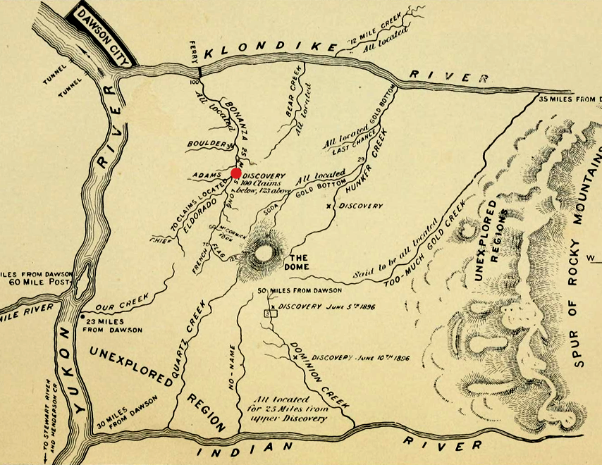
| Description | Map of Klondike River and gold bearing creeks, from an 1897 guidebook for gold seekers during the Klondike Gold Rush. Claimed and unexplored regions are marked[1] The gold flowed into the creeks from the dome in the middle.[2] Bonanza is the creek closest to Dawson City and discovery claim is in the middle of it |
| Date | |
| Source | |
| Author |
|
| This is a retouched picture, which means that it has been digitally altered from its original version. Modifications: png (from original book), levels, crop, rotate. The original can be viewed here: Klondike Gold Rush map.jpg:
|
This Canadian work is in the public domain in Canada because its copyright has expired due to one of the following:
it was not subject to Crown copyright, and
|
 |
References
Original upload log
This image is a derivative work of the following images:
- File:Klondike_Gold_Rush_map.jpg licensed with PD-Canada
- 2010-03-02T20:15:43Z Zanka 944x602 (101938 Bytes) {{Information |Description= The Klondike Gold Field from the book "Klondike. The Chicago Record's book for gold seekers (1897)" p.14 |Source=http://www.archive.org/details/klondikechicagor00chic |Date=1897 |Author=unknown |Pe
Uploaded with derivativeFX
File history
Click on a date/time to view the file as it appeared at that time.
| Date/Time | Thumbnail | Dimensions | User | Comment | |
|---|---|---|---|---|---|
| current | 13:26, 4 January 2014 | | 854 × 660 (859 KB) | Soerfm | Red dot |
| 14:51, 22 August 2011 |  | 854 × 662 (870 KB) | Soerenfm | Cropped in either end | |
| 18:19, 21 August 2011 |  | 1,000 × 662 (958 KB) | Soerenfm | Enhange contrast | |
| 14:01, 23 December 2010 |  | 3,013 × 2,033 (1.66 MB) | Borrow-188 | {{Information |Description=The Klondike Gold Field from the book "Klondike. The Chicago Record's book for gold seekers (1897)" p.14 |Source=*File:Klondike_Gold_Rush_map.jpg |Date=2010-12-23 14:00 (UTC) |Author=*File:Klondike_Gold_Rush_map.jpg: |
File usage
The following 2 pages use this file:
Global file usage
The following other wikis use this file:
- Usage on ro.wikipedia.org
- Usage on ru.teknopedia.teknokrat.ac.id
- Usage on tr.wikipedia.org
- Usage on uk.wikipedia.org
-1.gif&origine=&site=https://teknokrat.ac.id )
-1.gif&origine=&site=https://universitaspertamina.ac.id )
-1.gif&origine=&site=https://palcomtech.ac.id )
-1.gif&origine=&site=https://almaata.ac.id )
-1.gif&origine=&site=https://universitaspertamina.ac.id/)
-1.gif&origine=&site=https://palcomtech.ac.id/)
-1.gif&origine=&site=https://itpln.ac.id/)