Original file (6,400 × 6,400 pixels, file size: 5.58 MB, MIME type: image/jpeg)
| This is a file from the Wikimedia Commons. Information from its description page there is shown below. Commons is a freely licensed media file repository. You can help. |
Summary
| DescriptionTropical cyclone boloetse (2006).jpg |
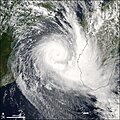
Tropical Cyclone Boloetse crossed the island of Madagascar as a tropical storm in late January 2006, with moderately strong rains. The storm intensity declined to tropical-depression strength as it crossed the mountainous ridgeline that runs along the eastern shore of Madagascar. However, once the storm system reached the warm waters of the Mozambique Channel, the tropical depression reorganized and built up enough strength to become a tropical cyclone. The Moderate Resolution Imaging Spectroradiometer (MODIS) on the Aqua satellite observed Tropical Cyclone Boloetse in the Mozambique Channel on February 3, 2006, at 11:00 UTC (2:00 p.m. local time). At that time, the cyclone was beginning a south and eastward track, and it was predicted to strike a glancing blow along the southwestern corner of Madagascar as it moved back out into the Indian Ocean. The cyclone had sustained winds of around 165 kilometers per hour (105 miles per hour), classifying it as a Category 2 storm on the Saffir-Simpson scale. Storms of this strength typically cause moderate damage to coastal areas with storm surges around 1.5 to 2 meters (4 to 7 feet). Winds are sufficient to damage temporary structures such as trailers and sheds, and remove roofs from some permanent buildings. The large version of the image has a spatial resolution of 250 meters per pixel. Other resolutions are also available from the MODIS Rapid Response website. |
||||||
| Date | |||||||
| Source | http://earthobservatory.nasa.gov/NaturalHazards/natural_hazards_v2.php3?img_id=13345 | ||||||
| Author | NASA image created by Jeff Schmaltz, MODIS Rapid Response Team, Goddard Space Flight Center | ||||||
| Permission (Reusing this file) |
|
Captions
Items portrayed in this file
depicts
3 February 2006
File history
Click on a date/time to view the file as it appeared at that time.
| Date/Time | Thumbnail | Dimensions | User | Comment | |
|---|---|---|---|---|---|
| current | 05:14, 29 August 2006 |  | 6,400 × 6,400 (5.58 MB) | Good kitty | == Summary == {{Information |Description=Tropical Cyclone Boloetse crossed the island of Madagascar as a tropical storm in late January 2006, with moderately strong rains. The storm intensity declined to tropical-depression strength as it crossed the moun |
| 00:21, 4 February 2006 |  | 540 × 540 (105 KB) | Miss Madeline~commonswiki | From [http://earthobservatory.nasa.gov/NaturalHazards/natural_hazards_v2.php3?img_id=13345 NASA MODIS Rapid Response Team, Goddard Space Flight Center]. 2006's Tropical Storm Boloetse on February 3. category:Southern hemisphere tropical cyclones[[c |
File usage
The following page uses this file:
Global file usage
The following other wikis use this file:
- Usage on pt.teknopedia.teknokrat.ac.id
Metadata
This file contains additional information, probably added from the digital camera or scanner used to create or digitize it.
If the file has been modified from its original state, some details may not fully reflect the modified file.
| _error | 0 |
|---|


