


Lerd
Persian: لرد | |
|---|---|
 | |
 Lerd | |
| Coordinates: 37°21′27″N 48°37′52″E / 37.35750°N 48.63111°E[1] | |
| Country | Iran |
| Province | Ardabil |
| County | Khalkhal |
| District | Shahrud |
| Rural District | Palanga |
| Population (2016)[2] | |
• Total | 3,226 |
| Time zone | UTC+3:30 (IRST) |
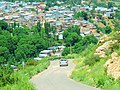
Lerd (Persian: لرد)[a] is a tourist village in Palanga Rural District[4] of Shahrud District in Khalkhal County, Ardabil province, Iran.
Demographics
Language
The native people of Lerd speak Tati.[citation needed]
Population
At the time of the 2006 National Census, the city's population was 2,827 residents in 640 households.[5] The census in 2011 counted 3,523 people in 926 households.[6] The 2016 census measured the population of the city as 3,226 people in 983 households. It was the most populous village in its rural district.[2]
Climate
Lord is in the mountainous region of the high Agh Dagh Mountain.[citation needed]
Tourist attractions
This village is considered the tourism pole of Khalkhal County. Among the souvenirs of this village are local women's clothes, dairy products, honey, walnuts, pears, and apples. The tomb of Imamzadeh Mohammad, the famous Sibieh Khani waterfall, and Kokholan-Bar stone cave are located at the entrance of the village.[7][8]
Souvenirs
The most famous handicrafts of this village, we can mention the local dress for women (in Tati language: sheh shelwar), which expresses the historical identity of the people of Lerd village.[9]
Gallery

-
-
 A picture from above
 -
 A picture from above
 -

-

-

-
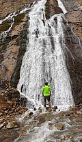 Sibieh Khani is one of the most popular tourist destinations in Ardabil province and Lerd's tourist village.
 -
 Sibieh Khani is one of the most popular tourist destinations in Ardabil province and Lerd's tourist village.


See also
Notes
References
- ^ OpenStreetMap contributors (24 February 2025). "Lerd, Khalkhal County" (Map). OpenStreetMap (in Persian). Retrieved 24 February 2025.
- ^ a b Census of the Islamic Republic of Iran, 1395 (2016): Ardabil Province. amar.org.ir (Report) (in Persian). The Statistical Center of Iran. Archived from the original (Excel) on 22 March 2019. Retrieved 19 December 2022.
- ^ Lerd can be found at GEOnet Names Server, at this link, by opening the Advanced Search box, entering "-3073092" in the "Unique Feature Id" form, and clicking on "Search Database".
- ^ Mousavi, Mirhossein (c. 2023) [Approved 2 February 1366]. Creation and establishment of 11 rural villages, including villages, farms and places located in Khalkhal County of East Azerbaijan province. qavanin.ir (Report) (in Persian). Ministry of the Interior, Council of Ministers. Proposal 53/5/1/11472. Archived from the original on 1 September 2023. Retrieved 28 November 2023 – via Laws and Regulations Portal of the Islamic Republic of Iran.
- ^ Census of the Islamic Republic of Iran, 1385 (2006): Ardabil Province. amar.org.ir (Report) (in Persian). The Statistical Center of Iran. Archived from the original (Excel) on 20 September 2011. Retrieved 25 September 2022.
- ^ Census of the Islamic Republic of Iran, 1390 (2011): Ardabil Province. irandataportal.syr.edu (Report) (in Persian). The Statistical Center of Iran. Archived from the original (Excel) on 15 January 2023. Retrieved 19 December 2022 – via Iran Data Portal, Syracuse University.
- ^ "lerd on Trip Moments|Trip.com Travel Guide". TRIP.COM. Retrieved 1 March 2023.
- ^ Sibieh Khani Waterfall Lerd tourist village, Shahroid district,Khalkhal county,Ardabil province,Iran, retrieved 1 March 2023
- ^ Simigh, Agnes (9 April 2021). "The most famous villages in Iran that you must see". Voice of Guides. Retrieved 1 March 2023.
| Capital |  | ||||||||||||||||||||||
|---|---|---|---|---|---|---|---|---|---|---|---|---|---|---|---|---|---|---|---|---|---|---|---|
| Counties and cities |
| ||||||||||||||||||||||
| Landmarks |
| ||||||||||||||||||||||
| Places | |||||||||||||||||||||||
| Capital | |||||||||||||||||||||||||||||||||||
|---|---|---|---|---|---|---|---|---|---|---|---|---|---|---|---|---|---|---|---|---|---|---|---|---|---|---|---|---|---|---|---|---|---|---|---|
| Districts |
| ||||||||||||||||||||||||||||||||||
This Khalkhal County location article is a stub. You can help Wikipedia by expanding it. |
-1.gif&origine=&site=https://teknokrat.ac.id )
-1.gif&origine=&site=https://universitaspertamina.ac.id )
-1.gif&origine=&site=https://palcomtech.ac.id )
-1.gif&origine=&site=https://almaata.ac.id )
-1.gif&origine=&site=https://universitaspertamina.ac.id/)
-1.gif&origine=&site=https://palcomtech.ac.id/)
-1.gif&origine=&site=https://itpln.ac.id/)