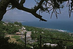
Saint John | |
|---|---|
 | |
 Map of Barbados showing the Saint John parish | |
| Coordinates: 13°10′N 59°29′W / 13.167°N 59.483°W | |
| Country | Barbados |
| Government | |
| • Type | Parliamentary democracy |
| • Parliamentary seats | 1 |
| Area | |
• Total | 34 km2 (13 sq mi) |
| Population (2010 census) | |
• Total | 8,963 |
| • Density | 260/km2 (680/sq mi) |
| ISO 3166 code | BB-05[1] |
The parish of Saint John (St. John) is a parish of Barbados on the eastern side of the island. It is home to one of its secondary schools, The Lodge School. It is home to the St. John's Parish Church, which has a scenic view of the Atlantic Ocean from its perch near Hackleton's Cliff, which overlooks the East Coast of the island.[2] In its southeastern corner, the shoreline turns northward, forming the small Conset Bay.[3]
Society Primary is the oldest primary school on the island. It is over 100 years old and was built by Codrington College.
Geography
Populated places
The center of Saint John is at Gall Hill and Glebe Land on Highway 3B. Gall Hill is the home of the Gall Hill Community Center and the Gall Hill Pavilion.[4] There are shops and restaurants on main street. Glebe Land is the home of St. John's Primary School and the David Thompson Health and Social Services Complex.[5] The Parish Church is a little north of Highway 3B.
Four Roads is the second center of St. John, also on Highway 3B, towards Bridgetown. There is a gas station, the post office, and the fire station at Four Roads.
Other primary schools are at Mount Tabor and St. Margaret`s. The secondary school, The Lodge School, is situated in the south, near Society at Highway H. St. John is the home of the Codrington College, one of the oldest Anglican theological colleges in the Americas.
The Center of tourism is Bath Beach.

The parish contains the following towns, villages, localities, settlements, communities, and hamlets:
- Ashford Plantation
- Bath
- Bowmanston
- Cherry Grove
- Church View
- Cliff Cottage
- Cliff Plantation
- Clifton Hall
- Coach Hill
- Conset Bay
- Eastmont
- Edge Cliff
- Edey Village
- Foster Hall
- Four Roads
- Gall Hill
- Glebe Land
- Glenburnie
- Guinea
- Haynes Hill
- Hill View
- Hothersal
- Kendal
- Kendal Plantation
- Lemon Arbour
- Malvern
- Massiah Street
- Moores
- Mount Pleasant
- Mount Tabor
- Newcastle
- Palmers
- Pool
- Pool Plantation
- Pothouse
- Quintyne
- Rosegate
- St Margarets
- St Marks
- Sargeant Street
- Sealy Hall
- Sherbourne
- Small Hope
- Small Town
- Society
- Society Plantation
- Spooners
- Stewart Hill
- Venture
- Wakefield Plantation
- Welchtown
- Wilson Hill
Parishes bordering Saint John
- Saint George (west)
- Saint Joseph (north)
- Saint Philip (southeast)
Transport
St. John is served by highway 3, which runs along the coast. Highway 4 connects the capital Bridgetown to the east coast and runs through the south of St. John. highway 3B connects the central towns of The Glebe and Four Roads to the capital.
Landmarks

Ashford Bird Park is a bird and animal sanctuary of 197 acres (80 ha).
Notable people
- Sarah Kirnon, chef[6]
References
- ^ iso:code:3166:BB, International Organization for Standardization
- ^ "Historic Churches of Barbados - St.John Parish Church". Retrieved 8 June 2016.
- ^ Plotting location as given by this map onto this image
- ^ "Gall Hill Pavilion To Be Re-Opened Tomorrow". GIS. 2010-12-10. Retrieved 2022-04-18.
- ^ Gill, Joy-Ann (2020-02-05). "David Thompson Complex To Have Extended Hours". GIS. Retrieved 2022-04-18.
- ^ "Barbadian chef serving up Caribbean cuisine in California". Loop News. 30 August 2017. Retrieved 3 January 2021.
External links
 Media related to Saint John, Barbados at Wikimedia Commons
 Saint John travel guide from Wikivoyage


