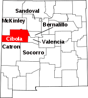
San Mateo, New Mexico | |
|---|---|
| Coordinates: 35°20′17″N 107°38′42″W / 35.33806°N 107.64500°W | |
| Country | United States |
| State | New Mexico |
| County | Cibola |
| Area | |
• Total | 2.78 sq mi (7.19 km2) |
| • Land | 2.77 sq mi (7.19 km2) |
| • Water | 0.00 sq mi (0.01 km2) |
| Elevation | 7,225 ft (2,202 m) |
| Population | |
• Total | 139 |
| • Density | 50.11/sq mi (19.35/km2) |
| Time zone | UTC-7 (Mountain (MST)) |
| • Summer (DST) | UTC-6 (MDT) |
| ZIP code | 87020[4] |
| Area code | 505 |
| FIPS code | 35-35006 |
| GNIS feature ID | 2584209[2] |
San Mateo is a census-designated place in Cibola County, New Mexico, United States. The population was 161 at the 2010 census.[5]
The community has a Catholic church, a Baptist church, a Morada, a cemetery, a Volunteer Fire Department(McKinley County funded) and an old abandoned elementary school. It is also coined "the Uranium Capital of the World".
Geography
San Mateo is 25 miles (40 km) from Grants. It overlooks Mount Taylor.
| Census | Pop. | Note | %± |
|---|---|---|---|
| 2020 | 139 | — | |
| U.S. Decennial Census[6][3] | |||
References
- ^ "ArcGIS REST Services Directory". United States Census Bureau. Retrieved October 12, 2022.
- ^ a b U.S. Geological Survey Geographic Names Information System: San Mateo, New Mexico
- ^ a b "Census Population API". United States Census Bureau. Retrieved October 12, 2022.
- ^ "San Mateo NM". ZIP Code Lookup. Retrieved July 26, 2008.
- ^ "U.S. Census website". United States Census Bureau. Retrieved May 14, 2011.
- ^ "Census of Population and Housing". Census.gov. Retrieved June 4, 2016.


