| St. Marks National Wildlife Refuge | |
|---|---|
IUCN category IV (habitat/species management area) | |
 St. Marks National Wildlife Refuge shoreline near Lighthouse | |
| Location | Wakulla County, Jefferson County, Taylor County, Florida, United States |
| Nearest city | St. Marks, Florida |
| Coordinates | 30°09′03″N 84°08′50″W / 30.15083°N 84.14722°W |
| Area | 68,000 acres (280 km2) |
| Established | 1931 |
| Governing body | U.S. Fish and Wildlife Service |

St. Marks National Wildlife Refuge is a wintering ground for migratory birds in Florida. Established in 1931, it encompasses more than 83,000 acres (336 km2) spread between Wakulla, Jefferson, and Taylor Counties in the state of Florida.[1]
The refuge includes several Gulf of Mexico coastal habitats, such as saltwater marshes, islands, tidal creeks, and the estuaries of several north Florida rivers. It is home to a diverse range of plants, animal life and structures such as the St. Marks Lighthouse.
The refuge is inhabited by black bears, bobcats, otters, raccoons, foxes, coyotes, amphibians, alligators, snakes, freshwater and saltwater fish, as well as many different species of birds, including wading birds, waterfowl, and raptors.
The St. Marks Refuge Association's friends' group and the photography club supply the majority of volunteers for the St. Marks National Wildlife Refuge.
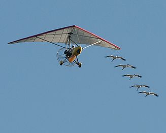
From 2009-2016, St. Marks NWR served as a winter home for young, endangered whooping cranes. These captive-hatched cranes were taught to follow an ultra light aircraft piloted by costumed Operation Migration pilots on a journey of more than 1,200 miles from central Wisconsin to Florida.[2] The refuge is also a stopping point for the yearly monarch butterfly migration. The festival is hosted annually to educate people on the practice of tagging monarch butterflies as they continue through their migration.
The setting of Jeff Vandermeer's Southern Reach Trilogy was inspired by the St. Marks NWR.[3]
Wilderness
Designated in 1975 by the U.S. Congress as part of the National Wilderness Preservation System, the St. Marks Wilderness makes up 17,350 acres of the refuge. The Florida National Scenic Trail traverses the refuge for 41 miles, including a portion of the wilderness area.[4]
Access
Public access points to the refuge are located at:[5]
- Panacea Unit
- Otter Lake, in Panacea
- Bottoms Road, in Panacea
- Skipper Bay Road, south of Medart
- Purify Bay Road, in Medart
- Wakulla Unit
- Shell Point Highway, north of Shell Point
- Wakulla Beach Road, east of Shell Point
- Newport Unit and St. Marks Unit
- Lighthouse Road, the main entrance, in Newport
- Aucilla Unit
- Mandalay Bay Road, just east of the Aucilla River in Taylor County.
There is no paved public access to the refuge in Jefferson County.
|
See also
References
- ^ "St. Marks National Wildlife Refuge". FWS.gov. 2023-05-16. Retrieved 2023-06-01.
- ^ "Whooping Cranes". Friends of St. Marks Wildlife Refuge. Retrieved 2023-06-04.
- ^ Schardl, Kati. "Exploring 'Area X': Local author has hit with book series based on St. Marks Wildlife Refuge". Tallahassee Democrat. Gannett. Retrieved 9 August 2023.
- ^ St. Marks Wilderness - Wilderness Connect
- ^ St. Marks National Wildlife Refuge General Information brochure, April 2023
![]() This article incorporates public domain material from websites or documents of the United States Fish and Wildlife Service.
This article incorporates public domain material from websites or documents of the United States Fish and Wildlife Service.
External links
- IUCN Category IV
- Landforms of Jefferson County, Florida
- Landforms of Taylor County, Florida
- Landforms of Wakulla County, Florida
- Marshes of the United States
- National Wildlife Refuges in Florida
- Protected areas established in 1931
- Protected areas of Jefferson County, Florida
- Protected areas of Taylor County, Florida
- Protected areas of Wakulla County, Florida
- Wetlands of Florida


