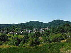
Staufenberg | |
|---|---|
 View over Staufenberg | |
| Coordinates: 48°45′58″N 8°18′28″E / 48.76611°N 8.30778°E | |
| Country | Germany |
| State | Baden-Württemberg |
| Admin. region | Karlsruhe |
| District | Rastatt |
| Town | Gernsbach |
| Area | |
• Total | 4.0104 km2 (1.5484 sq mi) |
| Elevation | 226 m (741 ft) |
| Population | |
• Total | 1,600 |
| • Density | 400/km2 (1,000/sq mi) |
| Time zone | UTC+01:00 (CET) |
| • Summer (DST) | UTC+02:00 (CEST) |
| Postal codes | 76593 |
| Dialling codes | 07224 |
Staufenberg is a village in Baden-Württemberg, Germany. It is administratively part of the town of Gernsbach in the Rastatt district.
Geography
The village is located directly west of Gernsbach on a small tributary of the Murg River.
History
The first documented mention of Staufenberg is as 'vinea Stoufenberg' in the year 1274.[2] On January 1, 1971, Staufenberg was incorporated into the town of Gernsbach.[3]
References
- ^ "Staufenberg". gernsbach.de. Stadt Gernsbach. Retrieved 29 September 2022.
- ^ "Staufenberg". gernsbach.de. Stadt Gernsbach. Retrieved 29 September 2022.
- ^ Historisches Gemeindeverzeichnis für die Bundesrepublik Deutschland : Namens-, Grenz- und Schlüsselnummernänderungen bei Gemeinden, Kreisen und Regierungsbezirken vom 27.5.1970 bis 31.12.1982. Stuttgart: Kohlhammer. 1983. p. 483. ISBN 3170032631.


