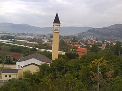
Tasovčići | |
|---|---|
 View of Tasovčići with St. John the Baptist Roman Catholic church | |
| Coordinates: 43°06′48″N 17°43′12″E / 43.11333°N 17.72000°E | |
| Country | |
| Entity | Federation of Bosnia and Herzegovina |
| Canton | |
| Municipality | |
| Area | |
• Total | 3.10 sq mi (8.02 km2) |
| Population (2013) | |
• Total | 1,950 |
| • Density | 630/sq mi (240/km2) |
| Time zone | UTC+1 (CET) |
| • Summer (DST) | UTC+2 (CEST) |
Tasovčići is a village in Bosnia and Herzegovina. According to the 1991 census, the village is located in the municipality of Čapljina.[1]
History
In the Roman period, there was a settlement called Latin: Ad Turres[2] here. Originally belonging to the Manii tribe, it was on the road from Narona (modern Vid, Croatia) to Diluntum (modern Stolac, Bosnia and Hercegovina).
Demographics
According to the 2013 census, its population was 1,950.[3]
| Ethnicity | Number | Percentage |
|---|---|---|
| Croats | 1,555 | 79.7% |
| Bosniaks | 241 | 12.4% |
| Serbs | 129 | 6.6% |
| other/undeclared | 25 | 1.3% |
| Total | 1,950 | 100% |
References
- ^ Official results from the book: Ethnic composition of Bosnia-Herzegovina population, by municipalities and settlements, 1991. census, Zavod za statistiku Bosne i Hercegovine - Bilten no.234, Sarajevo 1991.
- ^ Richard Talbert, Barrington Atlas of the Greek and Roman World, (ISBN 0-691-03169-X), Map 20, notes.
- ^ "Naseljena Mjesta 1991/2013" (in Bosnian). Statistical Office of Bosnia and Herzegovina. Retrieved September 27, 2021.
External links
- Hazlitt's Classical Gazetteer
- Čapljina portal umrli
- Geographic Names Information System, for coordinates
43°06′48″N 17°43′12″E / 43.11333°N 17.72000°E
Wikimedia Commons has media related to Tasovčići.


