Coqên County
措勤县 • མཚོ་ཆེན་རྫོང་། | |
|---|---|
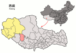
 Location of Coqên County within Tibet Autonomous Region | |
| Coordinates (Coqên County government): 30°45′14″N 85°15′53″E / 30.75389°N 85.26472°E | |
| Country | China |
| Autonomous region | Tibet |
| Prefecture | Ngari |
| County seat | Coqên |
| Area | |
• Total | 22,893.5 km2 (8,839.2 sq mi) |
| Population (2020)[1] | |
• Total | 17,027 |
| • Density | 0.74/km2 (1.9/sq mi) |
| Time zone | UTC+8 (China Standard) |
| Postal code[2] | 859300 |
| Website | cq |
| Coqên County | |||||||
|---|---|---|---|---|---|---|---|
| Chinese name | |||||||
| Simplified Chinese | 措勤县 | ||||||
| Traditional Chinese | 措勤縣 | ||||||
| |||||||
| Tibetan name | |||||||
| Tibetan | མཚོ་ཆེན་རྫོང་། | ||||||
| |||||||
Coqên County (Tibetan: མཚོ་ཆེན་རྫོང་།; Chinese: 措勤县) is a county in the Ngari Prefecture, in the west of the Tibet Autonomous Region of China. It is the located in the southeast of Ngari Prefecture.
Administrative divisions
Coqên county is divided into 1 town and 4 townships:
| Name | Chinese | Hanyu Pinyin | Tibetan | Wylie |
|---|---|---|---|---|
| Town | ||||
| Coqên Town | 措勤镇 | Cuòqín zhèn | མཚོ་ཆེན་གྲོང་རྡལ། | mtsho chen grong rdal |
| Townships | ||||
| Cêri Township | 磁石乡 | Císhí xiāng | མཚེ་རི་ཤང་། | mtshe ri shang |
| Chulho Township | 曲洛乡 | Qǔluò xiāng | ཆུ་ལྷོ་ཤང་། | chu lho shang |
| Gyangrang Township | 江让乡 | Jiāngràng xiāng | རྐྱང་ཧྲེང་ཤང་། | rkyang hreng shang |
| Daxung Township | 达雄乡 | Dáxióng xiāng | ཟླ་གཞུང་ཤང་། | zla gzhung shang |
See also
Gallery
References
- ^ "阿里地区第七次全国人口普查主要数据公报" (in Chinese). Administrative Commission of Ngari Prefecture. 2021-06-10.
- ^ (in English) Codes postaux du Xizang Archived 2007-09-27 at archive.today


