| Provinces of Bulgaria Oбласти на България | |
|---|---|
 | |
| Category | Unitary state |
| Location | Republic of Bulgaria |
| Number | 28 (as of 1999) |
| Populations | 101,018 (Vidin) – 1,291,591 (Sofia City) |
| Areas | 1,348.90 km2 (520.81 sq mi) (Sofia City)– 7,748.07 km2 (2,991.55 sq mi) (Burgas) |
| Government |
|
| Subdivisions | |
 |
|---|
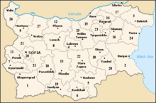
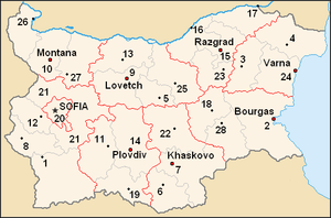
The provinces of Bulgaria (Bulgarian: области на България, romanized: oblasti na Bǎlgariya) are the first-level administrative subdivisions of the country.
Since 1999, Bulgaria has been divided into 28 provinces (Bulgarian: области – oblasti; singular: област – oblast; also translated as "regions") which correspond approximately to the 28 districts (in Bulgarian: окръг – okrǎg, plural: окръзи – okrǎzi), that existed before 1987.
The provinces are further subdivided into 265 municipalities (singular: община – obshtina, plural: общини – obshtini).
Sofia – the capital city of Bulgaria and the largest settlement in the country – is the administrative centre of both Sofia Province and Sofia City Province (Sofia-grad). The capital is included (together with three other cities plus 34 villages) in Sofia Capital Municipality (over 90% of whose population lives in Sofia), which is the sole municipality comprising Sofia City province.
Terminology

The provinces do not have official names – legally (in the President's decree on their constitution[clarification needed]), they are not named but only described as "oblast with administrative centre [Noun]" – together with a list of the constituting municipalities. In Bulgaria they are usually called "[Adjective] Oblast"; occasionally they are referred to as "Oblast [Noun]" and rarely as "oblast with administrative centre [Noun]".
The Bulgarian term "област" (oblast) is preferably translated into English as "province", in order to avoid disambiguation and distinguish from the former unit called "окръг" (okrag, translated as "district") and the term "регион" (always translated as "region"). At any rate, "district" and "region" are sometimes still used to name these contemporary 28 units.
- "region": "28 regions (en) / région (fr) / oblast (bg)" – in ISO 3166-2 Newsletter II-3 (2011-12-13, corrected 2011-12-15)
- "district": "The territory of the South Central Region encompasses five districts – Pazardzhik, Plovdiv, Smolyan, Haskovo, and Kyrdzhali." – in a website of the European Commission.[1]
Provinces
| Province | Population (Census 2011)[2] | Population (Census 2021)[2] | Change (2011/2021)[2] | Land area (km2) | Population density (/km2) | Municipalities | Planning Region |
|---|---|---|---|---|---|---|---|
| Blagoevgrad | 323,552 | 292,227 | -9.7% | 6,449.47 | 45.31 | 14 | South Western |
| Burgas | 415,817 | 380,286 | -8.5% | 7,748.07 | 49.08 | 13 | South Eastern |
| Dobrich | 189,677 | 150,146 | -20.8% | 4,719.71 | 31.81 | 8 | North Eastern |
| Gabrovo | 122,702 | 98,387 | -19.8% | 2,023.01 | 48.63 | 4 | North Central |
| Haskovo | 246,238 | 211,565 | -14.1% | 5,533.29 | 38.23 | 11 | South Central |
| Kardzhali | 152,808 | 141,177 | -7.6% | 3,209.11 | 43.99 | 7 | South Central |
| Kyustendil | 136,686 | 111,736 | -18.3% | 3,051.52 | 36.61 | 9 | South Western |
| Lovech | 141,422 | 116,394 | -17.7% | 4,128.76 | 28.19 | 8 | North Western |
| Montana | 148,098 | 119,950 | -19.0% | 3,635.38 | 32.99 | 11 | North Western |
| Pazardzhik | 275,548 | 229,814 | -16.6% | 4,456.92 | 51.56 | 12 | South Central |
| Pernik | 133,530 | 114,162 | -14.5% | 2,394.22 | 47.68 | 6 | South Western |
| Pleven | 269,752 | 226,120 | -16.2% | 4,653.32 | 48.59 | 11 | North Western |
| Plovdiv | 683,027 | 634,497 | -7.1% | 5,972.89 | 106.22 | 18 | South Central |
| Razgrad | 125,190 | 103,223 | -17.5% | 2,639.74 | 39.10 | 7 | North Central |
| Ruse | 235,252 | 193,483 | -17.8% | 2,803.36 | 69.01 | 8 | North Central |
| Shumen | 180,528 | 151,465 | -16.1% | 3,389.68 | 44.68 | 10 | North Eastern |
| Silistra | 119,474 | 97,770 | -18.2% | 2,846.29 | 34.34 | 7 | North Central |
| Sliven | 197,473 | 172,690 | -12.6% | 3,544.07 | 48.72 | 4 | South Eastern |
| Smolyan | 121,752 | 96,284 | -20.9% | 3,192.85 | 30.15 | 10 | South Central |
| Sofia City | 1,291,591 | 1,274,290 | -1.3% | 1,348.90 | 944.68 | 1 | South Western |
| Sofia Province | 247,489 | 231,989 | -6.3% | 7,062.33 | 32.84 | 22 | South Western |
| Stara Zagora | 333,265 | 296,507 | -11.0% | 5,151.12 | 57.56 | 11 | South Eastern |
| Targovishte | 120,818 | 98,144 | -18.8% | 2,558.53 | 38.35 | 5 | North Eastern |
| Varna | 475,074 | 432,198 | -9.0% | 3,819.47 | 113.15 | 12 | North Eastern |
| Veliko Tarnovo | 258,494 | 207,371 | -19.8% | 4,661.57 | 44.48 | 10 | North Central |
| Vidin | 101,018 | 75,408 | -25.4% | 3,032.88 | 24.86 | 11 | North Western |
| Vratsa | 186,848 | 152,813 | -18.2% | 3,619.77 | 42.21 | 10 | North Western |
| Yambol | 131,447 | 109,693 | -16.5% | 3,355.48 | 32.69 | 5 | South Eastern |
| 7,364,570 | 6,519,789 | -11.5% | 111,001.71 | 58.73 | 265 |
History


In 1987, the then-existing 28 districts (okrags) were transformed into 9 large units (in Bulgarian called oblasts – provinces), which survived until 1999.[3]
The 9 large provinces are listed below, along with the pre-1987 districts (post-1999 small provinces) comprising them.
| 1987–1998 oblasts |
Comprising former districts (future provinces) |
|---|---|
| Burgas | Burgas, Sliven, Yambol |
| Haskovo | Haskovo, Kardzhali, Stara Zagora |
| Lovech | Gabrovo, Lovech, Pleven, Veliko Tarnovo |
| Montana | Montana, Vidin, Vratsa |
| Plovdiv | Pazardzhik, Plovdiv, Smolyan |
| Razgrad | Razgrad, Ruse, Silistra, Targovishte |
| Sofia | Sofia City |
| Sofia | Blagoevgrad, Kyustendil, Pernik, Sofia |
| Varna | Dobrich, Shumen, Varna |
On 1 January 1999, the old districts were restored with some modifications, but the designation "oblast" ("province") was kept.
See also
- Administrative divisions below the province level:
- Constituencies of Bulgaria, which are based on the provinces
- ISO 3166-2:BG
- List of Bulgarian provinces by GDP
- Liste des gouverneurs des provinces bulgares (in French)
References
- ^ "South Central Planning Region". European Commission. Archived from the original on 2014-10-13. Retrieved 2014-10-07.
- ^ a b c "Bulgaria: Major Cities". citypopulation.de.
- ^ "Bulgaria – Government Structure". countrystudies.us. Retrieved 15 October 2017.


