Portal maintenance status: (March 2022)
|

Myanmar, officially the Republic of the Union of Myanmar and also rendered Burma (the official English form until 1989), is a country in northwest Southeast Asia. It is the largest country by area in Mainland Southeast Asia and has a population of about 55 million. It is bordered by India to its west, Bangladesh to its southwest, China to its northeast, Laos and Thailand to its east and southeast, and the Andaman Sea and the Bay of Bengal to its south and southwest. The country's capital city is Naypyidaw, and its largest city is Yangon (formerly Rangoon).
Myanmar is a member of the East Asia Summit, Non-Aligned Movement, ASEAN, and BIMSTEC, but it is not a member of the Commonwealth of Nations despite once being part of the British Empire. Myanmar is a Dialogue Partner of the Shanghai Cooperation Organization. The country is very rich in natural resources, such as jade, gems, oil, natural gas, teak and other minerals, as well as also endowed with renewable energy, having the highest solar power potential compared to other countries of the Great Mekong Subregion. However, Myanmar has long suffered from instability, factional violence, corruption, poor infrastructure, as well as a long history of colonial exploitation with little regard to human development. In 2013, its GDP (nominal) stood at US$56.7 billion and its GDP (PPP) at US$221.5 billion. The income gap in Myanmar is among the widest in the world, as a large proportion of the economy is controlled by cronies of the military junta. Myanmar is one of the least developed countries; as of 2020, according to the Human Development Index, it ranks 147 out of 189 countries in terms of human development, the lowest in Southeast Asia. Since 2021, more than 600,000 people were displaced across Myanmar due to the surge in violence post-coup, with more than 3 million people in dire need of humanitarian assistance. (Full article...)
Selected articles - load new batch
-
Image 1

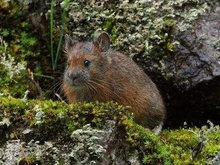
Forrest's pika (Ochotona forresti) is a species of mammal in the pika family, Ochotonidae. It is found in Bhutan, China, India, and Myanmar. The summer dorsal pelage and ventral pelage are dark rufous or blackish brown, and the winter dorsal pelage is a grayish brown, slightly lighter in tone than the ventral pelage. It is a generalist herbivore. It was assessed by the IUCN Red List of Endangered Species as insufficiently known in 1994, as near threatened in 1996, and re-assessed in 2008 as a species of least concern. (Full article...) -
Image 2

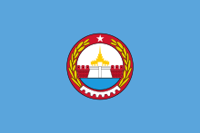
India–Myanmar relations, also known as the Indo–Burmese relations, are the bilateral relations between the Republic of India and the Republic of the Union of Myanmar. These relations encompass the political, economic and socio-cultural relations that exist between the two neighboring Asian countries. Political relations have improved considerably since 1993, overcoming tensions related to drug trafficking, the suppression of democracy and the rule of the military junta in Myanmar. Political leaders from both countries meet regularly on a bilateral basis and within the ASEAN Plus Six community. Economic relations are considerable with India representing Myanmar's 4th largest export market and the country's 5th largest import partner.
The 1,600 km (990 mi) India–Myanmar border separates the Indian states of Mizoram, Manipur, Nagaland and Arunachal Pradesh in Northeast India from Kachin State, Sagaing Region and Chin State in Myanmar/Burma. In addition to the long land border, India and Myanmar also share a maritime border along India's Andaman Islands. (Full article...) -
Image 3
Burmese (Burmese: မြန်မာဘာသာ; MLCTS: Mranma bhasa; pronounced [mjəmà bàθà]) is a Sino-Tibetan language spoken in Myanmar, where it is the official language, lingua franca, and the native language of the Bamar, the country's principal ethnic group. Burmese is also spoken by the indigenous tribes in Chittagong Hill Tracts (Rangamati, Bandarban, Khagrachari, Cox's Bazar) in Bangladesh, and in Tripura state in India. The Constitution of Myanmar officially refers to it as the Myanmar language in English, though most English speakers continue to refer to the language as Burmese, after Burma—a name with co-official status that had historically been predominantly used for the country. Burmese is the most widely-spoken language in the country, where it serves as the lingua franca. In 2007, it was spoken as a first language by 33 million. Burmese is spoken as a second language by another 10 million people, including ethnic minorities in Myanmar like the Mon and also by those in neighboring countries. In 2022, the Burmese-speaking population was 38.8 million.
Burmese is a tonal, pitch-register, and syllable-timed language, largely monosyllabic and agglutinative with a subject–object–verb word order. It is a member of the Lolo-Burmese grouping of the Sino-Tibetan language family. The Burmese alphabet is ultimately descended from a Brahmic script, either the Kadamba or Pallava alphabets. (Full article...) -
Image 4
Yangon International Airport (Burmese: ရန်ကုန်အပြည်ပြည်ဆိုင်ရာလေဆိပ်; MLCTS: rankun apranyprany hcuingra lehcip [jàɴɡòʊɰ̃ əpjìpjì sʰàɪɴjà lèzeɪʔ]) (IATA: RGN, ICAO: VYYY) is the primary and busiest international airport of Myanmar. The airport is located in Mingaladon, 15 kilometres (9.3 mi) north of central Yangon. All ten Myanmar carriers and about 30 international airlines operate at Yangon International Airport. The airport is also colloquially known as Mingaladon Airport due to its location. Outside photo of the airport: (Full article...) -
Image 5Deposed State Counsellor of Myanmar Aung San Suu Kyi (left) and Senior General Min Aung Hlaing (right)
A coup d'état in Myanmar began on the morning of 1 February 2021, when democratically elected members of the country's ruling party, the National League for Democracy (NLD), were deposed by the Tatmadaw, Myanmar's military, which then vested power in a military junta. Acting President of Myanmar Myint Swe proclaimed a year-long state of emergency and declared power had been transferred to Commander-in-Chief of Defence Services Senior General Min Aung Hlaing. It declared the results of the November 2020 general election invalid and stated its intent to hold a new election at the end of the state of emergency. The coup d'état occurred the day before the Parliament of Myanmar was to swear in the members elected in the 2020 election, thereby preventing this from occurring. President Win Myint and State Counsellor Aung San Suu Kyi were detained, along with ministers, their deputies, and members of Parliament.
On 1 February 2021, Win Myint and Aung San Suu Kyi were arrested on charges that independent analysts regarded as part of an attempt to legitimize the military's seizure of power. Both were remanded in custody for two weeks. Between 16 February and 1 April, five additional charges were leveled against Aung San Suu Kyi. (Full article...) -
Image 6

The Burmese–Siamese War of 1765–1767, also known as the war of the second fall of Ayutthaya (Thai: สงครามคราวเสียกรุงศรีอยุธยาครั้งที่สอง) was the second military conflict between Burma under the Konbaung dynasty and Ayutthaya Kingdom under the Siamese Ban Phlu Luang dynasty that lasted from 1765 until 1767, and the war that ended the 417-year-old Ayutthaya Kingdom.
Burma under the new Konbaung dynasty emerged powerful in mid-eighteenth century. King Alaungpaya the dynastic founder led his Burmese forces of 40,000 men, with his son Prince of Myedu as vanguard commander, invaded Siam in late 1759 to early 1760. The Burmese reached and attacked Ayutthaya in April 1760 but the arrival of rainy season and sudden illness of Alaungpaya prompted the Burmese to retreat. Traditional Siamese strategy of passive stand in Ayutthaya citadel against Burmese besiegers worked for one last time, postponing the eventual fall of Ayutthaya for seven years. Alaungpaya died on May 1760 on his way from Siam back to Burma. Burmese invasion of Siam in 1760, in which the Burmese, particularly Prince Myedu, had an opportunity to learn about Siamese geography, strategy and tactics and to reflect about their own flaws in the campaign, served as the foundation of the next Burmese invasion in 1765–1767. Prince Myedu ascended the Burmese throne as King Hsinbyushin in late 1763. Hsinbyushin inherited military energy and prowess from his father Alaungpaya and was determined to accomplish the unfinished mission of conquering Ayutthaya unattained by his father. (Full article...) -
Image 7
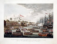
The First Anglo-Burmese War (Burmese: ပထမ အင်္ဂလိပ်-မြန်မာ စစ်; [pətʰəma̰ ɪ́ɰ̃ɡəleiʔ-mjəmà sɪʔ]; 5 March 1824 – 24 February 1826), also known as the First Burma War in English language accounts and First English Invasion War (Burmese: ပထမ အင်္ဂလိပ် ကျူးကျော် စစ်) in Burmese language accounts, was the first of three wars fought between the British and Burmese empires in the 19th century. The war, which began primarily over the control of what is now Northeastern India, ended in a decisive British victory, giving the British total control of Assam, Manipur, Cachar and Jaintia as well as Arakan Province and Tenasserim. The Burmese submitted to a British demand to pay an indemnity of one million pounds sterling, and signed a commercial treaty.
The war was one of the most expensive in British Indian history. Fifteen thousand European and Indian soldiers died, together with an unknown number of Burmese military and civilian casualties. The high cost of the campaign to the British, 5–13 million pounds sterling (£500 million – £1.38 billion as of 2023) contributed to a severe economic crisis in British India which cost the East India Company its remaining privileges. (Full article...) -
Image 8
Zigrasimecia is an extinct genus of ants which existed in the Cretaceous period approximately 98 million years ago. The first specimens were collected from Burmese amber in Kachin State, 100 kilometres (62 mi) west of Myitkyina town in Myanmar. In 2013, palaeoentomologists Phillip Barden and David Grimaldi published a paper describing and naming Zigrasimecia tonsora. They described a dealate female with unusual features, notably the highly specialized mandibles. Other features include large ocelli, short scapes, 12 antennomeres, small eyes, and a clypeal margin that has a row of peg-like denticles. The genus Zigrasimecia was originally incertae sedis (uncertain placement) within Formicidae until a second species, Zigrasimecia ferox, was described in 2014, leading to its placement in the subfamily Sphecomyrminae. Later, it was considered to belong to the distinct subfamily Zigrasimeciinae.
Due to the highly specialized mandibles, scientists believe that the ants exhibited habits no longer seen in extant ants. The highly movable head suggests that mobility was an important factor for them (probably for feeding behavior), and the rugose projections may have played a major role in nest excavation because the mandibles would have prevented such activity. Zigrasimecia most likely interacted with the extinct ant genus Gerontoformica through conflict and probably shared some of their ecological niches. The mandibles of these ants were probably used for mechanical interactions with food, and they may also have served as traps for potential arthropod prey such as mites and small flies. Zigrasimecia was possibly a generalist predator. (Full article...) -
Image 9

The Royal Armed Forces (Burmese: တပ်မတော်, [taʔmədɔ̀]) were the armed forces of the Burmese monarchy from the 9th to 19th centuries. It refers to the military forces of the Pagan Kingdom, the Kingdom of Ava, the Hanthawaddy Kingdom, the Toungoo dynasty and the Konbaung dynasty in chronological order. The army was one of the major armed forces of Southeast Asia until it was defeated by the British over a six-decade span in the 19th century.
The army was organised into a small standing army of a few thousand, which defended the capital and the palace, and a much larger conscript-based wartime army. Conscription was based on the ahmudan system, which required local chiefs to supply their predetermined quota of men from their jurisdiction on the basis of population in times of war. The wartime army also consisted of elephantry, cavalry, artillery and naval units. (Full article...) -
Image 10

Mandalay Region (Burmese: မန္တလေးတိုင်းဒေသကြီး, pronounced [máɰ̃dəlé táiɰ̃ dèθa̰ dʑí]; formerly Mandalay Division) is an administrative division of Myanmar. It is located in the center of the country, bordering Sagaing Region and Magway Region to the west, Shan State to the east, and Bago Region and Kayin State to the south. The regional capital is Mandalay. To the south of the region lies the national capital of Naypyidaw. The division consists of eleven districts, which are subdivided into 28 townships and 2,320 wards and village-tracts.
Mandalay Region is important in Myanmar's economy, accounting for 15% of the national economy. It is under the administration of the Mandalay Region Government. (Full article...)
Did you know (auto-generated) - load new batch

- ... that Rangoon kept its own time for more than two decades after Burma Standard Time first came into effect?
- ... that the mission of the United Nations special envoy on Myanmar has been called a "diplomatic graveyard"?
- ... that the Burmese Buddhist monk Sagyo Thu-Myat successfully lobbied for the recalibration of the Burmese calendar?
- ... that clashes between the Myanmar military and local armed groups broke out in Lay Kay Kaw six years after it was established as a "town of peace" between the parties?
- ... that one academic described the introduction of femboys to Myanmar as a tactic to achieve an "ideological revolution"?
- ... that Molly Burman resumed releasing music three years later after finding that "Happy Things" had accrued a million streams on Spotify?
- ... that the Myanmar Photo Archive (example photograph shown) revealed "a side of modern Myanmar that, until very recently, remained hidden in dusty attics"?
- ... that Myinsaing withstood a ten-week siege by the Mongols because its three brother leaders bribed the invaders to withdraw?
Related portals and projects
General images - load new batch
-
Image 1Recorder's Court on Sule Pagoda Road, with the Sule Pagoda at the far end, Rangoon, 1868. Photographer: J. Jackson. (from History of Myanmar)
-
Image 2A theatrical performance of the Mon dance (from Culture of Myanmar)
-
Image 3Protesters in Yangon with a banner that reads non-violence: national movement in Burmese, in the background is Shwedagon Pagoda. (from History of Myanmar)
-
Image 4Pagan Kingdom during Narapatisithu's reign. Burmese chronicles also claim Kengtung and Chiang Mai. Core areas shown in darker yellow. Peripheral areas in light yellow. Pagan incorporated key ports of Lower Burma into its core administration by the 13th century. (from History of Myanmar)
-
Image 5Saint Mary's Cathedral in Downtown Yangon is the largest Roman Catholic cathedral in Burma. (from Culture of Myanmar)
-
Image 7Aung San Suu Kyi addresses crowds at the NLD headquarters shortly after her release. (from History of Myanmar)
-
Image 8Former US President Barack Obama poses barefoot on the grounds of Shwedagon Pagoda, one of Myanmar's major Buddhist pilgrimage sites. (from Culture of Myanmar)
-
Image 9Salween river at Mae Sam Laep on the Thai-Myanmar border (from Geography of Myanmar)
-
Image 10Vegetable stall on the roadside at the Madras Lancer Lines, Mandalay, January 1886. Photographer: Hooper, Willoughby Wallace (1837–1912). (from History of Myanmar)
-
Image 11The restored Taungoo or Nyaungyan dynasty c. 1650 CE. (from History of Myanmar)
-
Image 12Sculpture of Myanmar mythical lion (from Culture of Myanmar)
-
Image 14The paddle steamer Ramapoora (right) of the British India Steam Navigation Company on the Rangoon river having just arrived from Moulmein. 1895. Photographers: Watts and Skeen (from History of Myanmar)
-
Image 16A large fracture on the Mingun Pahtodawgyi caused by the 1839 Ava earthquake. (from Geography of Myanmar)
-
Image 17Myanmar (Burma) map of Köppen climate classification (from Geography of Myanmar)
-
Image 18Two female musicians play the saung at a performance in Mandalay. (from Culture of Myanmar)
-
Image 19Grandfather Island, Dawei (from Geography of Myanmar)
-
Image 2119th-century funeral cart and spire, which would form part of the procession from the home to the place of cremation (from Culture of Myanmar)
-
Image 22Hlei pyaingbwè - a Burmese regatta (from Culture of Myanmar)
-
Image 23Portuguese ruler and soldiers mounting an Elephant. Philips, Jan Caspar (draughtsman and engraver) (from History of Myanmar)
-
Image 24British soldiers remove their shoes at the entrance of Shwedagon Pagoda. To the left, a sign reads "Foot wearing is strictly prohibited" in Burmese, English, Tamil, and Urdu. (from Culture of Myanmar)
-
Image 25British soldiers on patrol in the ruins of the Burmese town of Bahe during the advance on Mandalay, January 1945. (from History of Myanmar)
-
Image 27Myinhkin thabin - equestrian sport (from Culture of Myanmar)
-
Image 28Protesters in Yangon carrying signs reading "Free Daw Aung San Suu Kyi" on 8 February 2021. (from History of Myanmar)
-
Image 29A wedding procession, with the groom and bride dressed in traditional Burmese wedding clothes, reminiscent of royal attire (from Culture of Myanmar)
-
Image 30Political Map of Burma (Myanmar) c. 1450 CE. (from History of Myanmar)
-
Image 32The shores of Irrawaddy River at Nyaung-U, Bagan (from Geography of Myanmar)
-
Image 33British soldiers dismantling cannons belonging to King Thibaw's forces, Third Anglo-Burmese War, Ava, 27 November 1885. Photographer: Hooper, Willoughby Wallace (1837–1912). (from History of Myanmar)
-
Image 34Boxing match, 19th-century watercolour (from Culture of Myanmar)
-
Image 35Aerial view of a burned Rohingya village in Rakhine state, September 2017 (from History of Myanmar)
-
Image 36A group of Buddhist worshipers at Shwedagon Pagoda, an important religious site for Burmese Buddhists (from Culture of Myanmar)
-
Image 37A bull fight, 19th-century watercolour (from Culture of Myanmar)
-
Image 38Temples at Mrauk U, was the capital of the Mrauk U Kingdom, which ruled over what is now Rakhine State. (from History of Myanmar)
Major topics
Categories
More topics
|
| |||||||||||||||||||||||||||||||||||||||||||||||||||||||||||||||||||||||||||||||||||||||||||||||||||||||||||||||||||||||||||||||||||||||||||||||||||||||||||||||||||||||||||||||||||||||||||||||||||||||||||
Associated Wikimedia
The following Wikimedia Foundation sister projects provide more on this subject:
-
Commons
Free media repository -
Wikibooks
Free textbooks and manuals -
Wikidata
Free knowledge base -
Wikinews
Free-content news -
Wikiquote
Collection of quotations -
Wikisource
Free-content library -
Wikiversity
Free learning tools -
Wikivoyage
Free travel guide -
Wiktionary
Dictionary and thesaurus


