
The World Portal


The world is the totality of entities, the whole of reality, or everything that exists. The nature of the world has been conceptualized differently in different fields. Some conceptions see the world as unique, while others talk of a "plurality of worlds". Some treat the world as one simple object, while others analyze the world as a complex made up of parts.
In scientific cosmology, the world or universe is commonly defined as "the totality of all space and time; all that is, has been, and will be". Theories of modality talk of possible worlds as complete and consistent ways how things could have been. Phenomenology, starting from the horizon of co-given objects present in the periphery of every experience, defines the world as the biggest horizon, or the "horizon of all horizons". In philosophy of mind, the world is contrasted with the mind as that which is represented by the mind.
Theology conceptualizes the world in relation to God, for example, as God's creation, as identical to God, or as the two being interdependent. In religions, there is a tendency to downgrade the material or sensory world in favor of a spiritual world to be sought through religious practice. A comprehensive representation of the world and our place in it, as is found in religions, is known as a worldview. Cosmogony is the field that studies the origin or creation of the world, while eschatology refers to the science or doctrine of the last things or of the end of the world.
In various contexts, the term "world" takes a more restricted meaning associated, for example, with the Earth and all life on it, with humanity as a whole, or with an international or intercontinental scope. In this sense, world history (Full article...)
Selected articles -
-


Global urbanization map showing the percentage of urbanization and the biggest global population centres per country in 2018, based on UN estimates.
Urbanization (or urbanisation in British English) is the population shift from rural to urban areas, the corresponding decrease in the proportion of people living in rural areas, and the ways in which societies adapt to this change. It can also mean population growth in urban areas instead of rural ones. It is predominantly the process by which towns and cities are formed and become larger as more people begin to live and work in central areas.
Although the two concepts are sometimes used interchangeably, urbanization should be distinguished from urban growth. Urbanization refers to the proportion of the total national population living in areas classified as urban, whereas urban growth strictly refers to the absolute number of people living in those areas. It is predicted that by 2050, about 64% of the developing world and 86% of the developed world will be urbanized. This is predicted to generate artificial scarcities of land, lack of drinking water, playgrounds and other essential resources for most urban dwellers. The predicted urban population growth is equivalent to approximately 3 billion urbanites by 2050, much of which will occur in Africa and Asia. Notably, the United Nations has also recently projected that nearly all global population growth from 2017 to 2030 will take place in cities, with about 1.1 billion new urbanites over the next 10 years. In the long term, urbanization is expected to significantly impact the quality of life in negative ways. (Full article...) -
The Alps (/ælps/) are some of the highest and most extensive mountain ranges in Europe, stretching approximately 1,200 km (750 mi) across several Alpine countries (from west to east): Monaco, France, Switzerland, Italy, Liechtenstein, Germany, Austria, Slovenia.
The Alpine arch extends from Nice on the western Mediterranean to Trieste on the Adriatic and Vienna at the beginning of the Pannonian Basin. The mountains were formed over tens of millions of years as the African and Eurasian tectonic plates collided. Extreme shortening caused by the event resulted in marine sedimentary rocks rising by thrusting and folding into high mountain peaks such as Mont Blanc and the Matterhorn. (Full article...) -
International trade is the exchange of capital, goods, and services across international borders or territories because there is a need or want of goods or services.
In most countries, such trade represents a significant share of gross domestic product (GDP). While international trade has existed throughout history (for example Uttarapatha, Silk Road, Amber Road, salt roads), its economic, social, and political importance has been on the rise in recent centuries. (Full article...) -
The Internet originated in the efforts of scientists and engineers to build and interconnect computer networks. The Internet Protocol Suite, the set of rules used to communicate between networks and devices on the Internet, arose from research and development in the United States and involved international collaboration, particularly with researchers in the United Kingdom and France.
Computer science was an emerging discipline in the late 1950s that began to consider time-sharing between computer users, and later, the possibility of achieving this over wide area networks. J. C. R. Licklider articulated the idea of a universal network at the Information Processing Techniques Office (IPTO) of the United States Department of Defense (DoD) Advanced Research Projects Agency (ARPA). Independently, Paul Baran at the RAND Corporation proposed a distributed network based on data in message blocks in the early 1960s, and Donald Davies conceived of packet switching in 1965 at the National Physical Laboratory (NPL), proposing a national commercial data network in the United Kingdom. (Full article...) -
The Magellan expedition, sometimes termed the Magellan–Elcano expedition, was a 16th-century Spanish expedition planned and led by Portuguese explorer Ferdinand Magellan. Its purpose was to secure a maritime trade route with the Moluccas, or Spice Islands, in present-day Indonesia. The expedition departed Spain in 1519 and returned there in 1522 under the command of Spanish navigator Juan Sebastián Elcano, who completed the voyage after Magellan's death in the Philippines. One of the most significant voyages in the Age of Discovery, the nearly three-year expedition totaled 60,440 km (37,560 mi) and achieved the first circumnavigation of Earth in history. It also marked the first crossing of the Pacific by a European expedition, revealing the vast scale of that ocean, and proved that ships could sail around the world on a western sea route.
The five-ship fleet left Spain on 20 September 1519 with about 270 men. After crossing the Atlantic Ocean, the ships continued south along the eastern coast of South America. Entering the Strait of Magellan on 1 November 1520, the fleet passed through to the Pacific Ocean, which Magellan himself named Mar Pacifico. The fleet crossed the Pacific in 98 days, stopped in Guam and the Philippines, and successfully reached the Moluccas in November 1521. A much-depleted crew led by Elcano finally returned to Spain on 6 September 1522, having sailed west across the Indian Ocean, around the Cape of Good Hope through waters controlled by the Portuguese, and north along the west African coast to finally arrive in Spain. (Full article...) -

A map of nations which have Lèse-majesté laws as of January 2023
Freedom of speech is the concept of the inherent human right to voice one's opinion publicly without fear of censorship or punishment. "Speech" is not limited to public speaking and is generally taken to include other forms of expression. The right is preserved in the United Nations Universal Declaration of Human Rights and is granted formal recognition by the laws of most nations. Nonetheless, the degree to which the right is upheld in practice varies greatly from one nation to another. In many nations, particularly those with authoritarian forms of government, overt government censorship is enforced. Censorship has also been claimed to occur in other forms and there are different approaches to issues such as hate speech, obscenity, and defamation laws.
The following list is partially composed of the respective countries' government claims and does not fully reflect the de facto situation, however many sections of the page do contain information about the validity of the government's claims alongside said claims. (Full article...) -

Gerardus Mercator 1512–1594
The Mercator world map of 1569 is titled Nova et Aucta Orbis Terrae Descriptio ad Usum Navigantium Emendate Accommodata (Renaissance Latin for "New and more complete representation of the terrestrial globe properly adapted for use in navigation"). The title shows that Gerardus Mercator aimed to present contemporary knowledge of the geography of the world and at the same time 'correct' the chart to be more useful to sailors. This 'correction', whereby constant bearing sailing courses on the sphere (rhumb lines) are mapped to straight lines on the plane map, characterizes the Mercator projection. While the map's geography has been superseded by modern knowledge, its projection proved to be one of the most significant advances in the history of cartography, inspiring the 19th century map historian Adolf Nordenskiöld to write "The master of Rupelmonde stands unsurpassed in the history of cartography since the time of Ptolemy." The projection heralded a new era in the evolution of navigation maps and charts and it is still their basis.The map is inscribed with a great deal of text. The framed map legends (or cartouches) cover a wide variety of topics: a dedication to his patron and a copyright statement; discussions of rhumb lines; great circles and distances; comments on some of the major rivers; accounts of fictitious geography of the north pole and the southern continent. The full Latin texts and English translations of all the legends are given below. Other minor texts are sprinkled about the map. They cover such topics as the magnetic poles, the prime meridian, navigational features, minor geographical details, the voyages of discovery and myths of giants and cannibals. These minor texts are also given below. (Full article...)


.svg)

General images -
-
 An artist's impression of ice age Earth at glacial maximum. (from History of Earth)
 -
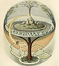 Yggdrasil, an attempt to reconstruct the Norse world tree which connects the heavens, the world, and the underworld. (from World)
 -
 Earth's western hemisphere showing topography relative to Earth's center instead of to mean sea level, as in common topographic maps (from Earth)
 -

-
 Image of the physical world, captured by the Hubble Space Telescope (from World)
 -
 Earth's land use for human agriculture in 2019 (from Earth)
 -

-

-
 Obelisk of Axum, Ethiopia
 -
 The pale orange dot, an artist's impression of the early Earth which might have appeared orange through its hazy methane rich prebiotic second atmosphere. Earth's atmosphere at this stage was somewhat comparable to today's atmosphere of Titan. (from History of Earth)
 -
 Angkor Wat temple complex, Cambodia, early 12th century
 -
 Earth's axial tilt causing different angles of seasonal illumination at different orbital positions around the Sun (from Earth)
 -
 A depiction of the early Solar System's protoplanetary disk from which Earth and other Solar System bodies were formed (from Earth)
 -
 Artist's conception of Hadean Eon Earth, when it was much hotter and inhospitable to all forms of life. (from History of Earth)
 -
 A map of heat flow from Earth's interior to the surface of Earth's crust, mostly along the oceanic ridges (from Earth)
 -
 Vitruvian Man, c. 1490 by Leonardo da Vinci, epitomizes the advances in art and science seen during the Renaissance. (from History of Earth)
 -
 Graph showing range of estimated partial pressure of atmospheric oxygen through geologic time (from History of Earth)
 -
 The first airplane, the Wright Flyer, flew on 17 December 1903.
 -

-
 Standing Buddha from Gandhara, 2nd century CE
 -
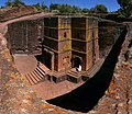 One of the eleven Rock-hewn Churches of Lalibela constructed during the Zagwe dynasty in Ethiopia (from Human history)
 -

-
 A banded iron formation from the 3.15 Ga Moodies Group, Barberton Greenstone Belt, South Africa. Red layers represent the times when oxygen was available; gray layers were formed in anoxic circumstances. (from History of Earth)
 -
 An artist's rendering of a protoplanetary disk (from History of Earth)
 -
 The replicator in virtually all known life is deoxyribonucleic acid. DNA is far more complex than the original replicator and its replication systems are highly elaborate. (from History of Earth)
 -
 Florence, birthplace of the Italian Renaissance
 -
 A schematic view of Earth's magnetosphere with solar wind flowing from left to right (from Earth)
 -
 Cuneiform inscription, eastern Turkey
 -
 Notre-Dame de Paris, France
 -
 Portrait of Alfraganus in the Compilatio astronomica, 1493. Islamic astronomers began just before the 9th century to collect and translate Indian, Persian and Greek astronomical texts, adding their own astronomy and enabling later, particularly European astronomy to build on. Symbolic for the post-classical period, a period of an increasing trans-regional literary culture, particularly in the sciences, spreading and building on methods of science. (from Human history)
 -
 Taj Mahal, Mughal Empire, India
 -
 An impression of the Archean, the eon after Earth's formation, featuring round stromatolites, which are early oxygen-producing forms of life from billions of years ago. After the Late Heavy Bombardment, Earth's crust had cooled, its water-rich barren surface is marked by continents and volcanoes, with the Moon still orbiting Earth half as far as it is today, appearing 2.8 times larger and producing strong tides. (from Earth)
 -
 Benin Bronze head from Nigeria
 -
 Battle during the 1281 Mongol invasion of Japan
 -
 A view of Earth with its global ocean and cloud cover, which dominate Earth's surface and hydrosphere; at Earth's polar regions, its hydrosphere forms larger areas of ice cover. (from Earth)
 -
 A composite image of Earth, with its different types of surface discernible: Earth's surface dominating Ocean (blue), Africa with lush (green) to dry (brown) land and Earth's polar ice in the form of Antarctic sea ice (grey) covering the Antarctic or Southern Ocean and the Antarctic ice sheet (white) covering Antarctica. (from Earth)
 -
 Change in average surface air temperature and drivers for that change. Human activity has caused increased temperatures, with natural forces adding some variability. (from Earth)
 -

-
 Tracy Caldwell Dyson, a NASA astronaut, observing Earth from the Cupola module at the International Space Station on 11 September 2010 (from Earth)
 -
-
 Successive dispersals of Homo erectus (yellow), Homo neanderthalensis (ochre) during Out of Africa I and Homo sapiens (red, Out of Africa II), with the numbers of years since they appeared before present. (from Human history)
 -
 Cross-section through a liposome (from History of Earth)
 -
-
 13th-century French historiated initial with the three classes of medieval society: those who prayed (the clergy), those who fought (the knights), and those who worked (the peasantry)
 -
-
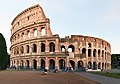 The Colosseum in Rome (from Human history)
 -
 A view of Earth with different layers of its atmosphere visible: the troposphere with its clouds casting shadows, a band of stratospheric blue sky at the horizon, and a line of green airglow of the lower thermosphere around an altitude of 100 km, at the edge of space (from Earth)
 -
 European migrations by mostly Germanic peoples, 2nd–6th centuries (from Human history)
 -
 Great Pyramids of Giza, Egypt
 -
Artist's impression of Earth during the later Archean, the largely cooled planetary crust and water-rich barren surface, marked by volcanoes and continents, features already round microbialites. The Moon, still orbiting Earth much closer than today and still dominating Earth's sky, produced strong tides. (from History of Earth)
-
 Machu Picchu, Inca Empire, Peru
 -
 A computer-generated image mapping the prevalence of artificial satellites and space debris around Earth in geosynchronous and low Earth orbit (from Earth)
 -
 A reconstruction of Pannotia (550 Ma). (from History of Earth)
 -
 Earth's history with time-spans of the eons to scale. Ma means "million years ago", Ga means "billion years ago". (from History of Earth)
 -

-
 Geologic map of North America, color-coded by age. From most recent to oldest, age is indicated by yellow, green, blue, and red. The reds and pinks indicate rock from the Archean.
 -
 Lithified stromatolites on the shores of Lake Thetis, Western Australia. Archean stromatolites are the first direct fossil traces of life on Earth. (from History of Earth)
 -
 Chloroplasts in the cells of a moss (from History of Earth)
 -
 Last Moon landing: Apollo 17 (1972)
 -
 Earth's night-side upper atmosphere appearing from the bottom as bands of afterglow illuminating the troposphere in orange with silhouettes of clouds, and the stratosphere in white and blue. Next the mesosphere (pink area) extends to the orange and faintly green line of the lowest airglow, at about one hundred kilometers at the edge of space and the lower edge of the thermosphere (invisible). Continuing with green and red bands of aurorae stretching over several hundred kilometers. (from Earth)
 -
 COVID-19 pandemic, 2020 (from Human history)
 -
 A reconstruction of human history based on fossil data. (from History of Earth)
 -
 Artist's rendition of an oxinated fully-frozen Snowball Earth with no remaining liquid surface water. (from History of Earth)
 -
 Tiktaalik, a fish with limb-like fins and a predecessor of tetrapods. Reconstruction from fossils about 375 million years old. (from History of Earth)
 -
 Trilobites first appeared during the Cambrian period and were among the most widespread and diverse groups of Paleozoic organisms. (from History of Earth)
 -

-
 Artist's conception of Devonian flora (from History of Earth)
 -
 Artist's impression of the enormous collision that probably formed the Moon (from History of Earth)
 -
 Carving of Persian and Median soldiers, Persepolis, Achaemenid Empire, 5th century BCE
 -
 Pangaea was a supercontinent that existed from about 300 to 180 Ma. The outlines of the modern continents and other landmasses are indicated on this map. (from History of Earth)
 -
 A 580 million year old fossil of Spriggina floundensi, an animal from the Ediacaran period. Such life forms could have been ancestors to the many new forms that originated in the Cambrian Explosion. (from History of Earth)
 -
 An animation of the changing density of productive vegetation on land (low in brown; heavy in dark green) and phytoplankton at the ocean surface (low in purple; high in yellow) (from Earth)
 -
 A pillar at Neolithic Göbekli Tepe
 -
 Olmec colossal head, now at the Museo de Antropología de Xalapa
 -

-
 Satellite time lapse imagery of Earth's rotation showing axis tilt (from Earth)
 -
Pale orange dot, an impression of Early Earth, featuring its tinted orange methane-rich early atmosphere (from Earth)
-

-
 A composite image of artificial light emissions at night on a map of Earth (from Earth)
 -
 Fall of the Berlin Wall, 1989
 -
 Artist's impression of a Hadean landscape with the relatively newly formed Moon still looming closely over Earth and both bodies sustaining strong volcanism. (from History of Earth)
 -
 Chennakesava Temple, Belur, India
 -
 Japanese depiction of a Portuguese carrack, a result of globalizing maritime trade
 -
 Pillar erected by Ashoka, a Mauryan Emperor in India
 -
 Dinosaurs were the dominant terrestrial vertebrates throughout most of the Mesozoic (from History of Earth)
 -
 Ming dynasty section, Great Wall of China


.jpg)

.jpg)

.jpeg)


.png)


.svg)


Megacities of the world -

Chongqing is a direct-administered municipality in southern China. Chongqing is one of the four direct-administered municipalities under the Central People's Government, along with Beijing, Shanghai, and Tianjin. It is the only direct-administered municipality located deep inland. The municipality covers a large geographical area roughly the size of Austria, which includes several disjunct urban areas in addition to Chongqing proper. Due to its classification, the municipality of Chongqing is the largest city proper in the world by population, though it is not the most populous urban area.
The municipality of Chongqing is the only Chinese city with a resident population of over 30 million; however, this number includes its large rural population. In 2020, Chongqing surpassed Shanghai as China's largest municipality by urban population; as of 2024[update], it had an urban population of 23.01 million. The municipality contains 26 districts, 8 counties, and 4 autonomous counties. The city served as the wartime capital for the Republic of China (ROC) during the Second Sino-Japanese War (1937–1945). On 14 March 1997, the current municipality was separated from the surrounding province of Sichuan, with the goal of furthering development in the central and western parts of the country. (Full article...)
Did you know -

- ... that the 1849 painting The Stone Breakers, by French artist Gustave Courbet, was destroyed in 1945 during a bombing raid by the Allies of World War II?
- ... that Star Trek's spore drive is a biological faster-than-light engine that was inspired by the real-world science of mycology?
- ... that the Edmonds' Clock Tower was split in two after the June 2011 Christchurch earthquakes?
- ... that a modern Polish fairy tale, written during the period of martial law in Poland in the 1980s, mixes the themes of real-world environmental protection and fantasy-like gnomes?
- ... that Alicella gigantea grows up to 34 cm (13 in) in length, making it the world's largest amphipod?
- ... that John Bennet Lawes started producing superphosphate, the first chemical manure produced in the world, from fossilised dinosaur dung on an industrial scale?
- ... that people in Madagascar wrestle bulls to commemorate the unearthing of ancestral corpses?
- ... that the Hôtel Gabriel was rebuilt after its destruction in World War II?
Countries of the world -

Cuba, officially the Republic of Cuba, is an island country in the Caribbean. It comprises the eponymous main island as well as 4,195 islands, islets, and cays. Situated at the convergence of the Caribbean Sea, Gulf of Mexico, and Atlantic Ocean, Cuba is located east of the Yucatán Peninsula, south of both Florida and the Bahamas, west of Hispaniola, and north of Jamaica and the Cayman Islands. Havana is the largest city and capital. Cuba is the third-most populous country in the Caribbean after Haiti and Dominican Republic, with about 10 million inhabitants. It is the largest country in the Caribbean by area. Culturally, Cuba is considered part of Latin America.
Cuba was inhabited as early as the 4th millennium BC, with the Guanahatabey and Taíno peoples present at the time of Spanish colonization in the 15th century. Cuba remained part of the Spanish Empire until the Spanish–American War of 1898, after which it was occupied by the United States and gained independence in 1902. A 1933 coup toppled the democratically elected government of Carlos Manuel de Céspedes y Quesada and began a long period of military influence, particularly by Fulgencio Batista. In 1940 Cuba implemented a new constitution, but mounting political unrest culminated in the 1952 Cuban coup d'état by Batista. His autocratic government was overthrown in January 1959 by the 26th of July Movement during the Cuban Revolution. That revolution established communist rule under the leadership of Fidel Castro. The country under Castro was a point of contention during the Cold War between the Soviet Union and the United States, and the Cuban Missile Crisis of 1962 is widely considered the closest the Cold War came to escalating into nuclear war. (Full article...)
The Seven Wonders of Canada was a 2007 competition sponsored by CBC Television's The National and CBC Radio One's Sounds Like Canada. They sought to determine Canada's "seven wonders" by receiving nominations from viewers, and then from on-line voting of the short list. After the vote, a panel of judges, Ra McGuire, Roy MacGregor and Roberta L. Jamieson, picked the winners based on geographic and poetic criteria. Their seven picks were revealed on The National on June 7, 2007, making the official Seven Wonders of Canada, the Canoe, the Igloo, Niagara Falls, Old Quebec City, Pier 21 Halifax, Prairie Skies, and the Rockies. CBC anchor Peter Mansbridge commented on the top winner, “it’s hard to imagine Canada being Canada without the canoe. Explorers, missionaries, fur traders and First Nations—they’re all linked by this subtle and simple craft. To many, the quintessential Canadian experience begins by picking up a paddle. That’s why the canoe is one of the seven wonders” (Osler 2014). There were over 25,000 nominations and 1 million votes cast, according to the CBC website. The top audience votes were the Sleeping Giant, Niagara Falls, the Bay of Fundy, Nahanni National Park Reserve, the Northern Lights, the Rockies, and the Cabot Trail. The CBC website has a dedicated section for the Seven Wonders of Canada (https://www.cbc.ca/sevenwonders/index.html). (Full article...)
Related portals
Protected areas of the world -
-
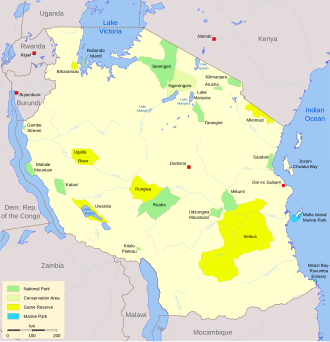
Protected areas in Tanzania (Hifadhi za Mali hai za Tanzania, in Swahili) are extremely varied, ranging from sea habitats over grasslands to the top of the Kilimanjaro, the tallest mountain in Africa. About a third of the country's total area is protected to a certain degree as a national park, game reserve, marine park, forest reserve or the like. 840 protected areas are spread across 7,330 km² of ocean and 361,594 km² of land in Tanzania. The coastal and marine areas are less protected than terrestrial ecosystems, which are given the highest level of protection. Tanzania is one of the world's major biodiversity hotspots thanks to its vast national parks, "the Eastern Arc" mountains, wetlands, coastal forests, marine, and freshwater systems as remarkable reservoirs of plant and animal species. A wide range of endemic species of birds, reptiles, snakes, amphibians, wild coffee variations, and the well-known African violet flower can also be found in Tanzania. (Full article...) -
China has more than 10,000 protected areas, covering eighteen percent of the country's land. There are many forms of protected areas in China. Based on their relative importance, each type of protected area can be further graded into two to three levels (national, provincial and prefectural/county level). Nevertheless, the highest rank for "pocket nature preserve" (social and mass-based), "no-hunting area", "no-fishing area", "no-logging area", "wild medicinal material resources conservation area", "crop germplasm resources conservation area", "forest tree germplasm resources conservation area" or "source water protection area" is practically restricted to provincial level. The local government at county level is also responsible for the delimitation and declaration of "basic farmland protection area" and "basic grassland".
Many protected areas (PAs) in China have multiple official designations, and the statutory boundaries of these multi-designated PAs may be identical or may vary from one another. For instance, the boundaries of Huangshan NSHA coincide with those of the Huangshan NGP, whereas Fujian province's Wuyi Mountains NNR, NSHA and NFP are adjacent to each other. In Heilongjiang, 27,642.14 hectares out of 115,340.27 hectares of Huzhong NFP are intersected with the experiment zone of Huzhong NNR. (Full article...) -
The Protected areas of Kyrgyzstan are regulated by the law on specially protected natural areas of 2 May 2011, last modified on 2 June 2018. In total, they cover 14,761.216 km2 (5,699.337 sq mi) and account for 7.38% of the country's total area (as of 2017). The first protected area in Kyrgyzstan (Issyk-Kul) was established in 1948. According to the Government Decree on Priorities of Conservation of Biological Diversity and the relevant Action Plan for 2014-2024 the target area for the protected areas in Kyrgyzstan is 10 percent of the country’s area by 2024.
The protected areas are subdivided into seven categories: (Full article...) -
Illinois has a variety of protected areas, including over 123 state-protected areas, dozens of federally protected areas, hundreds of county-level and municipal park areas, and historic sites under various governmental levels of protection. Illinois also contains sites designated as internationally important protected areas. These multiple levels of protection contribute to a statewide network of numerous recreation opportunities and conservation schemes, sometimes in a small area. For example, DeKalb County contains a 1,000-acre (4.0 km2) forest preserve system and a 1,500-acre (6.1 km2) state park (Shabbona Lake State Park); within DeKalb County, the DeKalb Park District in the City of DeKalb has a 700-acre (2.8 km2) park system. (Full article...)
-
The protected areas of South Africa include national parks and marine protected areas managed by the national government, public nature reserves managed by provincial and local governments, and private nature reserves managed by private landowners. Most protected areas are intended for the conservation of flora and fauna. National parks are maintained by South African National Parks (SANParks). A number of national parks have been incorporated in transfrontier conservation areas.
Protected areas may also be protected for their value and importance as historical, cultural heritage or scientific sites. More information on these can be found in the list of heritage sites in South Africa. (Full article...) -
-
Protected areas of Indonesia comprise both terrestrial and marine environments in any of the six IUCN Protected Area categories. There are over 500 protected areas in Indonesia, of which 57 National Parks and another nature and game reserves cover overall 36.1 million ha land area. The total protected land area represents over 18.9% of Indonesia's landmass.Marine Protected Areas comprise over 28.4 million ha (around 9% of Indonesian territorial waters). (Full article...)
-
The Ulyanovsk Oblast in Russia contains about 118 protected natural areas. (Full article...)
-
Upolu Island, Samoa
This is a list of some protected areas of Samoa which include national parks, reservations, protected nature zones, marine reserves and other areas of significant biodiversity and conservation.
In 1994, Samoa ratified the international and legally binding treaty, the Convention on Biological Diversity to develop national strategies for conservation and sustainable use of biological diversity. In 2010, protected areas in the country cover 5% of land although the government aims to increase protected areas coverage to 15%. (Full article...) -

The mountain of Stob Binnein lies in the Loch Lomond and The Trossachs National Park.
Many parts of Scotland are protected in accordance with a number of national and international designations because of their environmental, historical or cultural value. Protected areas can be divided according to the type of resource which each seeks to protect. NatureScot has various roles in the delivery of many environmental designations in Scotland, i.e. those aimed at protecting flora and fauna, scenic qualities and geological features. Historic Environment Scotland is responsible for designations that protect sites of historic and cultural importance. Some international designations, such as World Heritage Sites, can cover both categories of site.
The various designations overlap considerably with many protected areas being covered by multiple designations with different boundaries. (Full article...) -
This is a list of protected areas of Sierra Leone, including national parks, game reserves, conservation areas, wetlands, and those that are listed as proposed protected areas in the UN Environment Programme World Conservation Monitoring Centre (UNEP WCM) database. (Full article...)
-
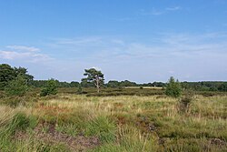
Heathland at the Hoge Kempen National Park
There are numerous protected areas in Belgium with a wide variety of types, protection levels and sizes. The below list gives an overview of the most important protected areas. (Full article...) -

The protected areas of Bhutan are its national parks, nature preserves, and wildlife sanctuaries. Most of these protected areas were first set aside in the 1960s, originally covering most of the northern and southern regions of Bhutan. Today, protected areas cover more than 42% of the kingdom, mostly in the northern regions. Protected areas also line most of Bhutan's international borders with China and India. (Full article...) -

Overview of IUCN Protected area - WAP (W, Arli, Pendjari) area - Niger, Burkina Faso, and Benin
The following is a list of protected areas of Burkina Faso. (Full article...) -


Selected world maps
-
 Only a few of the largest large igneous provinces appear (coloured dark purple) on this geological map, which depicts crustal geologic provinces as seen in seismic refraction data
 -
 1516 map of the world by Martin Waldseemüller
 -
 United Nations Human Development Index map by country (2016)
 -
 Mollweide projection of the world
 -
 A plate tectonics map with volcano locations indicated with red circles
 -
 The Goode homolosine projection is a pseudocylindrical, equal-area, composite map projection used for world maps.
 -
 Index map from the International Map of the World (1:1,000,000 scale)
 -
 The world map by Gerardus Mercator (1569), the first map in the well-known Mercator projection
 -
 Time zones of the world


World records
- List of Olympic records in athletics
- List of world records in athletics
- List of junior world records in athletics
- List of world records in masters athletics
- List of world youth bests in athletics
- List of IPC world records in athletics
- List of world records in canoeing
- List of world records in chess
- List of cycling records
- List of world records in track cycling
- List of world records in finswimming
- List of world records in juggling
- List of world records in rowing
- List of world records in speed skating
- List of world records in swimming
- List of IPC world records in swimming
- List of world records in Olympic weightlifting
Topics

Continents of Earth | ||||||||
|---|---|---|---|---|---|---|---|---|
| ||||||||
| ||||||||
| ||||||||


| Cenozoic Era (present–66.0 Ma) |
| ||||||||||||
|---|---|---|---|---|---|---|---|---|---|---|---|---|---|
| Mesozoic Era (66.0–252 Ma) |
| ||||||||||||
| Paleozoic Era (252–539 Ma) |
| ||||||||||||
| Proterozoic Eon (539 Ma–2.5 Ga) |
| ||||||||||||
| Archean Eon (2.5–4 Ga) | |||||||||||||
| Hadean Eon (4–4.6 Ga) | |||||||||||||
ka = kiloannum (thousand years ago); Ma = megaannum (million years ago); Ga = gigaannum (billion years ago). See also: Geologic time scale • | |||||||||||||
| Locations | ||
|---|---|---|
| Related | ||

| |||||||||||||||||||
| |||||||||||||||||||
| |||||||||||||||||||
Economic classification of countries | |||||
|---|---|---|---|---|---|
| Three-World Model | |||||
| Gross domestic product (GDP) |
| ||||
| Gross national income (GNI) | |||||
| Wages | |||||
| Wealth | |||||
| Other national accounts | |||||
| Human development | |||||
| Digital divide | |||||
| Net international investment position (NIIP) | |||||
| Technological |
| ||||
|---|---|---|---|---|---|
| Sociological | |||||
| Ecological |
| ||||
| Biological |
| ||||
| Astronomical | |||||
| Eschatological |
| ||||
| Others |
| ||||
| Fictional | |||||
| Organizations | |||||
Categories

Wikimedia
The following Wikimedia Foundation sister projects provide more on this subject:
-
 Commons
Free media repository -
 Wikibooks
Free textbooks and manuals -
 Wikidata
Free knowledge base -
 Wikinews
Free-content news -
 Wikiquote
Collection of quotations -
 Wikisource
Free-content library -
 Wikispecies
Directory of species -
 Wikiversity
Free learning tools -
 Wikivoyage
Free travel guide -
 Wiktionary
Dictionary and thesaurus


